12 August, 2022
☙ Dobbiaco ❧
No surprise. My train from Zermatt to Visp arrived on time - precisely on time. I had a full 4 minutes to catch the train to Brig. This took less than two. Missing this connection would have torpedoed the day, so I was thankful for the extra minute. At Brig I boarded Trenitalia to Verona. It was a nice train and I splurged (not very much) on a first class ticket to Milan, just to see what it would be like - and, in my baggies and hoody, lowered the bar of sartorial splendor. We entered the Simplon tunnel and emerged 20 km later to the sight of the tile roofs of Iselle and the turquoise waters of the Lago Toce. "Mascherina." prompted the conductor, walking down the aisle. I was in Italy.
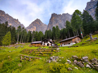
Getting from Zermatt to Villabassa, a small village in Italy's South Tyrol would take 12 hours, and 5 train transfers, and one broken train causing a small change in routing (and some tear-streaming hilarity from the passengers). The journey was a pleasant one along the edge of the Italian Alps through Milan, Verona, and Bolzano before the last transfer to a regional train that snuck up on the Dolomites along their northern flank through the Val Pusteria. It passed the starting point of the first three Alta Vias before arriving at Dobbiaco. I would backtrack to the beginning of the Alta Via 3 in the morning.
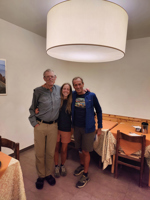 Dinner Date
Claudio and Anna, his daughter were waiting at the platform. Her text messages had saved the day, and I arrived on the evening train. They were in shorts and tees - I was overdressed for dinner. I had met them on the Alta Via 2 three years earlier, and despite time, distance and Covid, we had kept in touch. They had made the 2½ hour drive from their home in Treviso for a quiet dinner and ostensibly, an exchange of photos - theirs from the GR20 on Corsica and mine from the Walker's Haute Route in the Swiss Pennines. I felt immediately at home in their easy, casual presence. We spent little time looking at pictures though, instead sharing dreams and passions, and cooking up a plan to walk the Alta Via 4 the following summer. It was a magical evening and too short for soon they were on their way home. I realized I had made two friends in this far away place - and that the walk ahead might just be a bit more lonely ...
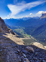
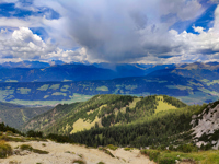 Sarlsattel View
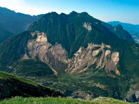
I caught the 8:00 am bus back to Dobbiaco and after a quick visit to a sports shop, caught another for the 10 minute ride to Villabassa. I started two hours later than I should have and this delay would make for an exciting afternoon. There was one short meadow, then the route climbed a wildly steep forest road with corrugated concrete pads in a few really steep sections and ended at a small cafe. I grabbed a quick cappuchino and a pastry, then started up an even steeper path with a series of exposed switchbacks and traverses, finally reaching a small saddle 600 meters higher and the boundary of the Fanes-Senes-Brais Nature Park, one of many areas in the Dolomites where there has been success in balancing preservation with hundreds of years of traditional agricultural use. To the north from the Sarlsattel a great swath of Val Pusteria was visible with peaks of the Austrian alps behind. In every other direction lay the Dolomites. Most of the day was still before me and from this viewpoint, I realized just how long it would be. I had Pico di Vallandro to traverse and 400 meters of climbing to finish before the end of the day.
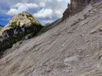 Detour
The first few kilometers went pretty quickly, then I encountered the first of a series of alluvial fans surrounding Pico di Vallandro. It was huge and lay at the angle of repose. Given a nudge, a stone could roll and bounce for hundreds of meters before coming to rest. A hundred meter swath of the path across the first of these, which extended 500 meters downslope, was washed away. What had been established since was thin and loose, and I was happy to put it behind me. I had just finished the next section of grass- and tree-covered terraces to the corner of Pico di Vallandro and the second scree slope when thunder began to the west. On the far side of the slope was a tree line with some rock overhangs and I though I could make it to there. Midway across, the rain began. Fortunately, it was mostly small hail and not soaking the rubble. Unfortunately, I could see that lightning was not far behind. In five minutes I was in the trees and found a small cozy cave. This would do.
It hailed and snowed for nearly 45 minutes. I covered my legs with my jacket and watched a spectacular lightning display on Croda Rossa to the west. I was reminded of the happy creatures from Fantasia as the wind died and the snow turned to a light on and off drizzle with patches of sun breaking through on the nearby peaks. I could hear rockfall far above the last and largest scree field ahead but nothing seemed to be reaching the path. I gave things a few minutes to settle down then crossed the mushy slope. Ahead lay a series of long alpine meadows strewn along the skirt of the peak, and after an hour along these, there appeared a small rifugio flying a flag. As I drew near, I could hear rock music. I opened the door to the sounds of AC/DC and Angus Young banging out the left-handed intro to . There was a group of young people dancing and preparing for a party later that day. One welcomed me with a cup of hot chocolate and led me to a chair. "Too loud?" she asked. I shook my head - I loved the song. A couple of older guys were playing chess but interrupted their game to set a glass of hot rum-laced cider next to the cocoa, shouting over the rock and roll that only the completely drunk could fail to make Rifugio Vallandro now only 10 minutes away. While I dried off and warmed up they explained with certainty that this was the one day of summer snow for the Dolomites and that it would not affect my plans. After a second glass of cider, I said goodbye and walked to the rifugio, reaching it just as the kitchen was closing.
I was scolded for missing dinner, then given a huge plate filled with what was left - potatoes with cheese and spiced cabbage. Apparently there were more leftovers for once I had emptied my plate, it was taken away and refilled. I asked about grappa, and the manager brought two bottles to the table and sat down. I chose the bottle infused with a sprig of pine, and she poured one for each of us. She said there were several ways to continue the AV2 and gave me some tips for the next section. She said it had been a busy summer, with a lot of Americans. I asked her if we had behaved ourselves. She only shrugged.
With the day ending in a somewhat unlikely success, I attempted some polite small talk with two Slovakian women sharing the otherwise empty dorm room. One spoke a little english, but the other was quiet and shy, and I failed to make her smile. We talked only a little for we all had ambitious plans. In a few minutes the shy one was snoring so I put in my earplugs and switched off the lights.
 Descent from Vandelli
From Rifugio Vallandro, a good road descended all the way back to Carbonin, returning me to where I had spent the night of my arrival. To get from here to Rifugio Vandelli, one had to either walk a few suicidal kilometers along the road to rejoin the official path or take a bus to where an alternate route left the road at Misurina. I took the woman's advice and chose the second, then walked to Passo Tre Croci via a quiet side valley. I didn't know whether this particular weekend was a holiday, but the roadside was packed with cars and people filled the trails. On the path to Rifugio Vandelli there were hundreds of people returning from a day hike to the very popular lake near the rifugio. Folks had their dogs and children, some crying, some barking and some being carried. One exposed section of trail equipped with cable was so choked with people descending that those of us going up took to the nearby ledges rather than wait for the end of the endless procession.
Eventually I reached the rifugio, now occupied only by those staying the night. Some were returning to Passo Tre Croci the next day and others were planning to exit this huge cirque via one of two popular via ferratas. The country is famous for her via ferratas. They are mountain routes protected by systems of cables and ladders, and are synonymous with Italy. It is customary for only the "consequential" ground to be "wired". For some, that means too much cable, for others, too little. The cable is typically about 10 mm in diameter - thick enough to hold an automobile and withstand significant rockfall. It is anchored to the rock with expansion pins and epoxy. In recent years the iron cable and anchors have been replaced with stainless steel. The rope is clamped taut to the pins. The via ferrata "kit" consists of a helmet, harness, and a pair of tethers with quick release carabiners. These are clipped alternately between anchors to insure that you don't fall off in case you slip or are beaned by rockfall. From there it is simple - you just enjoy the mountains and take in the scenery.
I fell in love with the girl at the desk. She was undeniably attractive and personable, and I struggled not to stare at the white dirndl - I am old, but not that old. I asked her name. "Angelica," she replied. What else would it be, I thought. She seemed immune to the attention and now - having stolen my heart - was all business as she showed me to my bunk and my place in the dining room. The bar was outside, it was quiet, and the sun was shining. Only another smile could have made this day better.
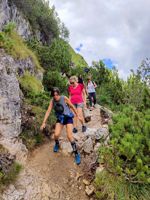
 Starting the traverse
The Ferrate from the Rifugio Vandelli, the "Vandelli" and "Berti" are widely know and very popular. I chose the Ferrata Berti because of its character and tendency to be overlooked in favor of the shorter and more accessible Feratta Vandelli. The "Berti" includes an airy traverse along scree ledges midway up the massive S. face of Croda Marcora - a sub-summit of Sorapiss - just to reach the beginning of the cables. Reaching the start of the traverse is itself not trivial. About 150 meters of 4th class climbing is required to gain the ledges, technical enough to make for an unpleasant down-climb. One might reasonably expect cables here, but I found none. At the corner turning onto the shelf, there is an intimidating view across the path ahead and over the Val del Boite - filled with tiny villages 1,500 meters below - but it is a straightforward walk, the only hazard being rockfall from the cliffs above.
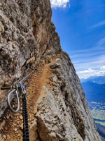 Last Cable
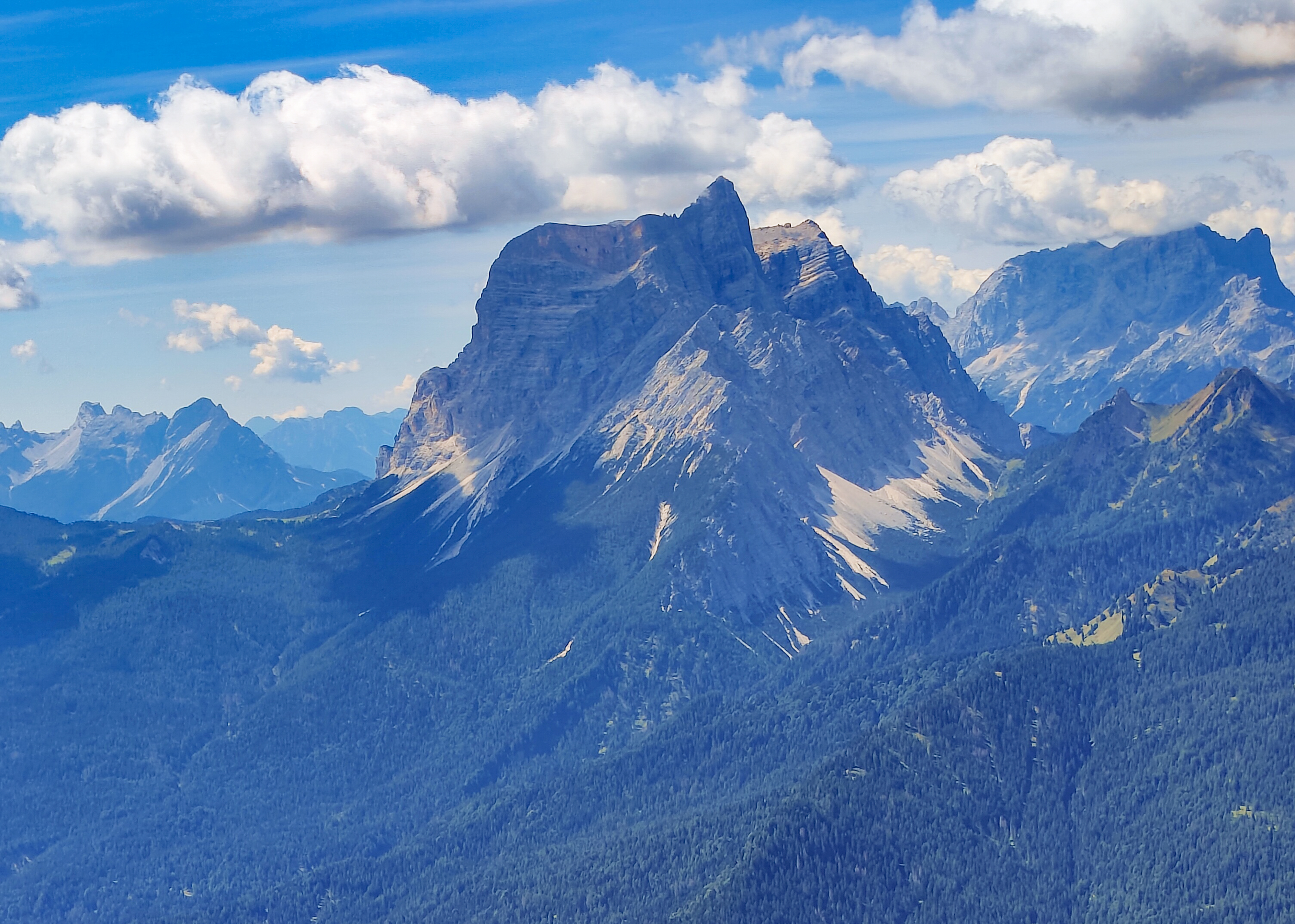
After about an hour of careful walking along the dizzyingly perched terrace, I reached the first cable protecting a short section of cliffs. There was a 200 meter gap to the start of the next cable, and the route became wildly exposed, living up to the hype. There was some honest 5th class climbing and a substantial amount of vertical required to gain the final, spectacular section which exited abruptly onto a large plateau with a fantastic view to the western Dolomites - Marmolada, Civetta, Tofane and Pelmo dominating the view. 1700 meters below was San Vito de Cadore and my hotel. The walk down was long but pleasant, first traversing grassy hillsides to Forcella Grande with sublime views south to Marmarole, then steeply down to funky Rifugio San Marco for a sandwich and a cold beer. The trail continued its steep descent for a short way, then followed a service road surrounded by pine forest to the town. The woman at the hotel greeted me by name and recommended a place for dinner. It had been a very long but very gratifying day in the most remarkable setting.
Unfortunately this day started out with a quartet of older, disturbingly ugly Americans at breakfast who offended guests and staff alike. I kept quiet and when I checked out, apologized to the manager. She returned a resigned smile and a small shrug then said, "We understand English very well." I left, wondering how my silence had been perceived: acceptance, indifference, or cowardice?
I fumed for the thousand meters to Rifugio Venezia, regretting that I had taken the coward's path in avoiding confrontation. My guilty reward was a private room and a "birra grande" to start the evening. There were only a few people in the sala commune - among them the two Slovakians from Rifugio Vallandro. I joined them with my beer and smiled at the shy one and this time she smiled back. They had done the Ferrata Berti yesterday as well and had their sights set on Monte Pelmo tomorrow. That would put me ahead of them for a while, but I suspected, not for long. Monte Pelmo - a UNESCO World Heritage Site - is right outside the door. It exceeds 3000 meters (lofty for the Dolomites). There is an easy but exposed route to the summit. I am told that most parties dispense with a rope because anchors are so poor. I had toyed with including a couple of ascents in my itinerary but couldn't fit them in. Now I found myself wishing I had tried harder, for Pelmo looked very inviting. I rationalized my regret away with the thought that tomorrow's walk of 19 km to Passo Cibiana would be plenty. After dinner the wifi quit, and everyone looked up from their phones. There was an old guitar on the wall. One of the staff tuned it up and sang a few songs, Italian ones, but I only recognized a few words here and there.
 The Bosconeros
There wasn't a cloud in the sky. The Slovakians and I were the only ones up for the early breakfast. "Dobrý deň" said the shy one with a second, now easier smile. Two Italian gents were also doing the Pelmo but they had left earlier - something about meeting their wives for lunch after the climb.
Today's stage of the AV3 would share parts of the Anello Zoldano - another multi-day mountain path specific to the Val di Zoldo - to Monte Rite, site of the Messner Mountain Museum, then down a very steep path and road to my bed for the night at Passo Cibiana, the only road south of Cortina to connect the Val del Boite with the Val di Zoldo to the west.
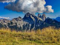
The path first traversed high meadows filled with the sounds of cowbells then wandered through a series of thick, forested hills of larch and fir until the final climb to the summit of Monte Rite - festooned with communications towers and the glass-covered WWI gun emplacements comprising the museum. These fortifications were to repel the Austrians, but the guns were never fired, for the enemy never advanced that far south. On the map, Monte Rite is an easily overlooked feature, seemingly insignificant. Its location however - in the middle of nowhere - yields a 360° view that defies superlatives. Nearly every major peak and mountain group of the Dolomites is visible, and those nearest - the towers of the Rochetta and Sasso Di Bosconero to the south - are sublime.
 Forcella de la Ciavazole
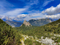
The path from Passo Cibiana was delightful. It climbed through larch and beech forests strewn with mushrooms and late season flowers. I met one family along the otherwise deserted way. The last 100 meters to the high point at Forcella de la Ciavazole broke out into a landscape of barren limestone and dwarf pines. Here at 2,000 meters, the views of the previous five days would be replaced by those of the last - one long day given good weather or a stopover at Bivouac Tovanella if not. In the event of a worst case forecast, I would descend to the valley and catch a bus to Belluno, ending my outing in this sweet country.
The descent from Forcella de la Ciavazole had a reputation. At the beginning of the descent "Experts Only' was painted in red on a large rock. A few meters below, the path degenerated into a scree slope swept bare by gravity. Sections of rope were fixed here and there through the worst parts. Some had been damaged or severed by rockfall. Boots and gaiters were definitely the ticket for the 250 meter descent back into the comfort of the remaining forested path to the rifugio. I was far past descending ground like this in a pair of "high-tech" sneakers.
 Rifugio Bosconero
On a bench overlooking the Val di Zolda some 1200 meters below and literally at the foot of the Rocchetta Alta and Sasso di Bosconero is perched Rifugio Bosconero, a destination for anyone descending from the Forcella de la Ciavazole or coming from the valley. This area is particularly attractive to climbers. It offers difficult, sustained routes on steep, high quality rock. A girl watching her boyfriend and his partner on Rocchetta Alta said the route they were on was a UIAA 7 - equivalent to an american 5.10 and for a 700 meter, essentially vertical wall, a serious undertaking. Some watched, clucking baseless concern. I remembered 3 am returns to the valley after Teton climbs so I would reserve mine until I saw headlamps on the wall, and I told the girl as much. Just as it became dark, lights appeared, not on the wall, but in the descent couloir, and around eight-thirty the boys showed-up, laughing and lugging two haul bags. They had finished-off a big wall climb, equivalent (from my Teton perspective) to the North Face of the Grand, in a day! After a beer and plate of pasta, the three of them headed for their car 2 hours below. It had been another good day.
Among the dwindling patrons were a very nice British couple, Josh and Grace, also doing the AV3. They had arrived the day before, but Josh had sprained his ankle descending from the forcella and spent last night here at Bosconero hoping for enough improvement to continue. It didn't look like that would happen for anyone though, since the weather forecast was bad, and the last stage was the hardest and wildest of the walk - with little opportunity to bail. Josh was a bit despondent, so I fetched a bottle of grappa and under Grace's watchful eye, we insured that the only direction we would be going tomorrow was down ...
Everyone in the iron-roofed dorm was awakened at 5 am by a violent thunderstorm that lasted for perhaps an hour. The flashes and sound were simultaneous. One person intent on a photo-op went outside until the next terrifying flash sent her scurrying back inside. I think the lightning could have actually been striking the building. The morning's storm and the forecast for the day came true, putting an end to any hope of finishing the walk along the high and exposed ridgecrest of the Viaz de le Ponte. The decision was a wise one. Everyone donned what raingear they had and started down the path to the road. Soon it started to rain again in earnest. I walked with the Brits - our tempo marked by the squish of their sneakers. The downpour was literally like standing in a shower and it lasted for nearly a hour with uninterrupted thunder reverberating off the walls around us. We reached the small village of Forno di Zoldo, got an hour break from the rain, and just managed to board the bus to Longarone when the downpours resumed. The insane road down the gorge of the Torrente Maè clings to the mountainside for much of the 20 kilometers to Longarone. Along the way, the bus stopped at a flashing red construction light. It was pouring and hard to see anything from the windows, but when it turned green and we continued, I looked down and saw that one lane of the road had fallen into the gorge.
 Monte Toc
Longarone was the scene of a tragedy that occurred in 1963 when a huge landslide poured from Monte Toc into the nearly-filled reservoir behind the newly constructed Vajont hydro project dam some 260 meters high, then one of the highest structures of its type in the world. The structure held, but millions of cubic meters of water displaced by the earth poured into the valley below, destroying 7 villages and killing as many as 2000 people, some of whose remains are still being uncovered. The story is worth the read.
 Fresh Fruit
The village seemed cursed still, for once I was on the bus to Belluno, the weather cleared and the short trip along the Fiume Piave was over almost before it had begun. The Stazione Centrale was familiar from the Alta Via 1 in 2018 and in contrast with the first trip, I found the hotel quickly. The same guy, with his bald head and pencil perched on his ear, was still behind the desk. Since then though, the place had been upgraded with central air conditioning and automated lighting, and was now missing the funky charm I remembered. I have a crush on Belluno, perhaps for no other reason than my life-long, indiscriminate predilection for love at first sight. I wandered the streets, visited the museum, listened to a symphony rehearsal, sampled "Lingua" (quite by accident), grew fat on bottomlesss gelatos, and fell in love with la cameriere - all in two short days. My flight home was at 11. On the way to the station for the 7 am train to Venice, I passed a produce shop and bought a bag of fruit, not thinking that what I could not eat on the train would probably be seized at security, but the staff at the checkpoint was Italian, and the fruit was "not a problem". By the time I reached Atlanta, it would be gone ...
Anna Akhmatova
 ;
;